Navigating Under the Paradise Island Bridges: What You Need to Know
There are so many reasons why yacht owners and captains decide to make Hurricane Hole Superyacht Marina — but they need to get here first to see everything the best marina in The Bahamas has to offer. To do so, it’s important to know the basics about the two Paradise Island bridges that connect this beautiful island with New Providence, the most populous Bahamas island just across the water from us.
Luckily, the team at Hurricane Hole Superyacht Marina is here for you, with the information and tips you’ll need to plan your arrival and departure and safely and easily navigate under the two Paradise Island bridges. Let’s get started with the basics.
A Quick Look at the Two Paradise Island Bridges
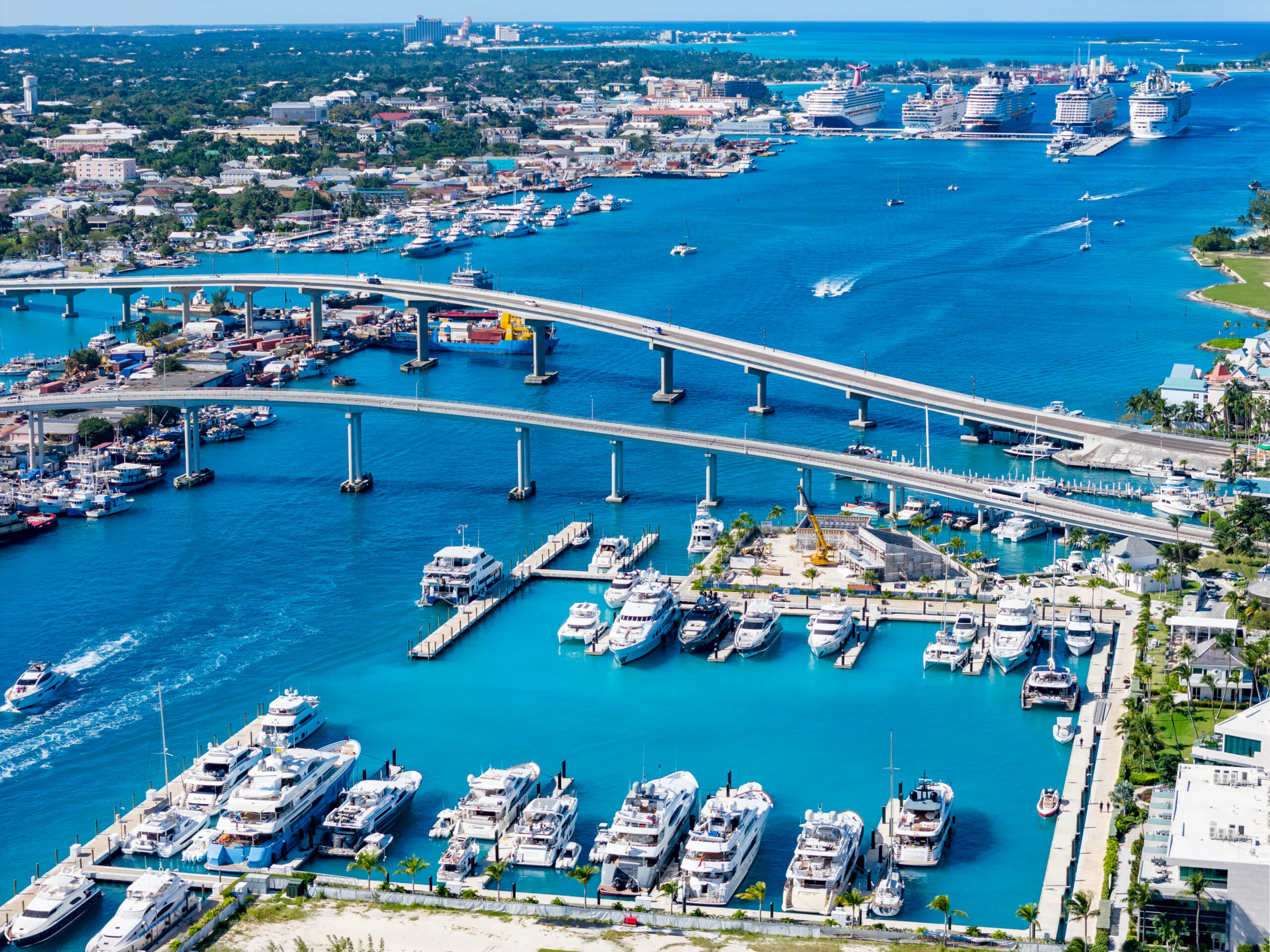
Owned by The Government of The Commonwealth of The Bahamas, there are two Paradise Island bridges that connect this island with Nassau and New Providence. Each bridge operates 24 hours a day, seven days a week.
While each of the Paradise Island bridges is built with pre-stressed concrete material with a cantilever-type construction, there are some major differences between the two that drivers, boaters, and pedestrians need to know.
The Basics of the Eastern Bridge
The eastern bridge, which is 1,560 feet long and has 36 feet of two lanes of vehicular traffic, includes pedestrian sidewalks on each sidewalk that are about 5 feet wide. It’s rated for a maximum weight/load limit of 15 tons and first opened to traffic in April 1967. It received a renovation in 1998 and again in 2016.
The Western Bridge: The Sir Sidney Poitier Bridge
While it was simply referred to as the “western bridge” at first when it opened in December 1998, this newer, bigger bridge eventually was given a new honorific name in 2012: The Sir Sidney Poitier Bridge.
The newer of the two Paradise Island bridges, The Sir Sidney Poitier Bridge is 1,930 feet long and 52 feet wide, with three lanes of traffic and four toll booth lanes, and includes a 7-foot-wide single pedestrian sidewalk. It has a weight and load limit of 25 tons and a 17.5-foot maximum height clearance for its canopy.
Each of the two Paradise Island bridges carries traffic in just one direction, both serving an important role to easily link Paradise Island with New Providence.
Navigating Under the Two Paradise Island Bridges
Now that you know the basics and history of the bridges, let’s get to the crucial details that yachters and boaters need to know: How to navigate under the two Paradise Island bridges.
Both are 70 feet above sea level at their highest points, and both are operated and maintained by The Bridge Authority, which has the same role for all bridges in The Commonwealth of The Bahamas.
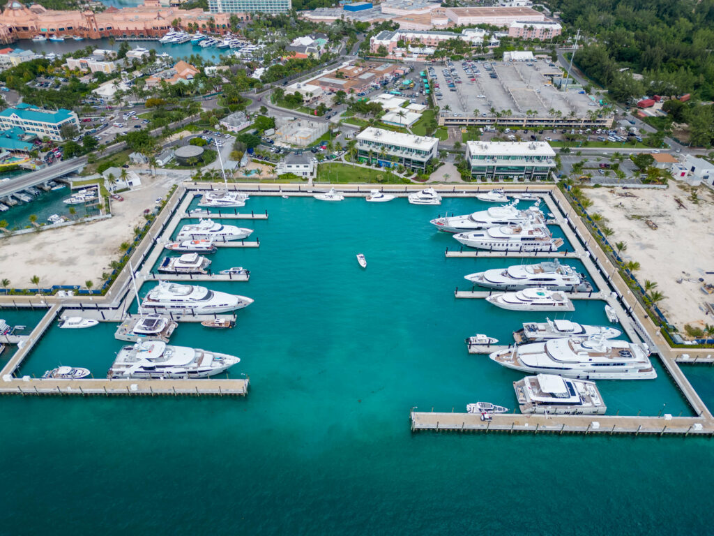
Hurricane Hole Superyacht Marina is located east of both Paradise Island bridges, and vessels can access the marina from either the east or west. It’s important to know that this top Bahamas marina is a deep-water facility with a deep draft, and we can accommodate even the largest superyachts.
So, how do you access Hurricane Hole Superyacht Marina? If you come in from the west, you’ll be navigating the wider and deeper-dredged part of the harbour. However, this path requires clearing under both Paradise Island bridges, which may be too low for large sailing yachts and some catamarans.
Approaching from the east, instead, the harbour isn’t as well-dredged, and boats will face a draft that can be difficult to navigate unless the operator is familiar with the area and is coming in at high tide.
Either side of access has its own benefits and drawbacks, so it’s important to plan ahead and determine which route is best for your vessel.
We Look Forward to Hosting You at Hurricane Hole Superyacht Marina
Once you’re here, you’ll realize just why Hurricane Hole Superyacht Marina has become known as the best marina in The Bahamas. Take, for example, our premier fuel services, including the first and only in-slip fueling available at a Bahamas marina. Please note that 48 hours is required for this state-of-the-art and convenient fueling option, with a minimum of 1,500 gallons and diesel only. In-slip fueling is available Monday through Friday, and there is a $0.10/gallon convenience fee.
There is no minimum purchase at Hurricane Hole Superyacht Marina’s fuel dock, located between the two Paradise Island bridges. The fuel dock is open 8 a.m. to 5 p.m. seven days a week, and is open to the public and transient vehicles. Contact the fuel dock staff on VHF channels 16 & 11.
Hurricane Hole Superyacht Marina also boasts 24-hour security, top internet and communications infrastructure, and a total of 6,100 linear feet of deep-water docks, including fixed concrete docks as well as floating docks that rise and fall with the tides.
With a 240-foot-wide turning basin, 70-foot bridge clearance, a maximum depth of 14.5 feet, and slips up to 420 feet, Hurricane Hole Superyacht Marina is ready to accommodate just about any yacht.
We’re also proud to offer an array of conveniences and amenities for visitors, including an exclusive Captain’s Lounge and Crew Gym, secure parking facilities, laundry machines and ice, and on-site concierge services, in addition to close proximity to stores, restaurants, and medical facilities.
Contact our team online, call 242-603-1950, or book your slip online, and get ready to be impressed by the top amenities and services we have to offer. We look forward to seeing you!